MapSafe Data Sovereignty Tool

MapSafe offers a complete approach to safeguard geospatial data by obfuscating, encrypting and notarising it.
These functions run client-side in your browser meaning geospatial data never leaves your computer unprotected.

About Mapsafe

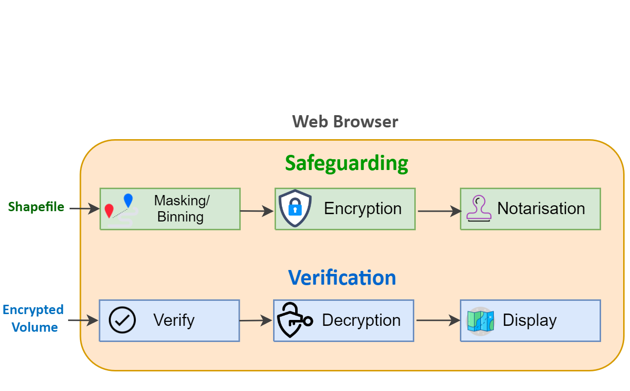
MapSafe completely safeguards sensitive geospatial datasets using obfuscation, encryption, and notarisation. These functions are implemented within the browser using popular open source JavaScript libraries without ever requiring users to install or download any software.

Whether you're a GIS expert, a GIS researcher, or a newbie, if you need to safeguard your geospatial data but aren't quite sure how, MapSafe makes your life easier and brings previously cumbersome geospatial data safeguarding methods into reach.

Img

SAFEGUARDING

MapSafe uses three techniques to completely safeguard sensitive geospatial datasets.
These techniques are carried out in a sequential order.

Geospatial Masking

MapSafe first allows users to use geomasking or binning functions to obfuscate coordinates. This allows users to share maps with approximate locations without overly affecting any spatial patterns, while preventing exposing sensitive data or violating anyone's privacy.

Encryption

The masked geospatial dataset is further protected using encryption where the original data is transformed into a form unrecoverable by an adversary. MapSafe uses the Web.Cryto toolkit library which is in-built within the web browser.

Notarisation

Finally, MapSafe generates a hash value of the encrypted obfuscated geospatial data and notarises it as a public record on the tamper-proof Ethereum blockchain. This approach guarantees that the digital signature remains unchanged can be used for verification of encrypted datasets.

Verification

The verification process compares the before and after hash values of the encrypted file, after which the user can proceed with the decryption and display of the dataset.

Verification

The sovereign party loads the encrypted data, while MapSafe generates a hash value for verification against the hash stored in the blockchain. Matching values signify the volume has not been tempered with, and the user can then proceed with decryption.

Decryption

Decryption uses the encrytion key to transform the encrypted data back into the original form. Based on the recipients privilege, a passphrase of certain length will be shared using which the user decrypts to a certain encrypted level, containing different representations of the original data.

Display

In the final step, the geospatial dataset of different resolutions is displayed. Based on their privilege, users will see either the original or a masked representation of the original dataset.